GEBCO Bathymetry Heightmap 5400x2700
Video Lecture

Resources
1 x 8bit and 16bit Images of 5400x2700
1 pixel per 4 minutes latitude
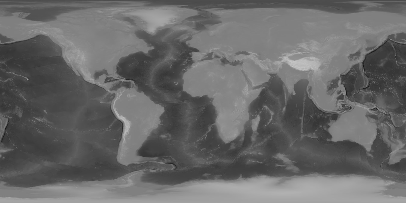
Attribution: Heightmaps based on GEBCO 2020 Grid and preprocessed by Sean Bradley : https://sbcode.net/topoearth/gebco-heightmap-5400x2700/#license
Download 5400x2700 JPEG with 8bit height values : See License
Download 5400x2700 TIFF with 16bit height values : See License
Source Data
Images and Data used to create the above image and linked images was created from the GEBCO Grid and can be downloaded from GEBCO Gridded Bathymetry Data
Disclaimer
- The GEBCO Grid should NOT be used for navigation or for any other purpose involving safety at sea.
- The GEBCO Grid is made available 'as is'. While every effort has been made to ensure reliability within the limits of present knowledge, the accuracy and completeness of The GEBCO Grid cannot be guaranteed. No responsibility can be accepted by GEBCO, IHO, IOC, or those involved in its creation or publication for any consequential loss, injury or damage arising from its use or for determining the fitness of The GEBCO Grid for any particular use.
- The GEBCO Grid is based on bathymetric data from many different sources of varying quality and coverage.
- As The GEBCO Grid is an information product created by interpolation of measured data, the resolution of The GEBCO Grid may be significantly different to that of the resolution of the underlying measured data.
License
- Data and images created from the source data and provided on this page as images and other data formats, should NOT be used for navigation, safety or any other purpose where precise data is required.
- Data and images created from the source data and provided on this page as images and other data formats, is sourced from various other data sets of varying quality and have may have their own further license requirements attached.
- Any modifications to the source data are Copyright 2020 © Sean Bradley and are provided without any warranty of any kind, express or implied.
- All the source data used to create the images and data further provided by this site was obtained from public domain data sources.
- Any repurposed data may have been amplified, simplified or adjusted in some other way intended for the purpose of using in my 3d modelling tutorials.
- My name, Sean Bradley, or this website cannot be used in any way that suggests endorsement of any further derived products created from the images and data supplied by this website or my courses without specific prior written permission.
- If you use the images provided by this website, you must attach an attribution link to this page that shows the license and disclaimers so that any further users are aware of the sources, limitations and quality of the data provided by this website.
- The attribution should be visible enough and easily accessible for users so that they are aware of the conditions contained in the licenses and disclaimers.
Attribution
The images provided on this website are repurposed from publicly available source data.
You can do this to, however my reproductions,
- are unique,
- they are not the same as you find on the source data websites,
- they were interpreted using closed source code also written by me to reproduce the outputs provided for free on these web pages.
- All differences from the original source data are Copyright 2020 © Sean Bradley.
- Any usage of the images downloaded from this website must contain attribution pointing to this web page.
E.g.,
1 | |